1869 mAP OF mARLBOROUGH
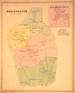
Map Name: Marlborough
Date of map: 1869
Description: Colored map of Marlborough, showing businesses, schools and districts, and homes. Also includes inset of the Marlborough Mills area in the north end of the town.
Sources: Collection of the Marlborough Historical Society
Notes: Original map taken from, “Atlas of Hartford City and County: with a map of Connecticut, from actual surveys”. Baker & Tilden, 1869.
Posted on July 12, 2007 11:44 AM
1869 Map of Marlborough - inset
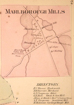
Map Name: Marlborough Mills
Date of map: 1869
Description: Inset from colored map of Marlborough, showing businesses, schools and districts, and homes. The inset shows the Marlborough Mills area in the north end of the town.
Sources: Collection of the Marlborough Historical Society
Notes: Original map taken from, “Atlas of Hartford City and County: with a map of Connecticut, from actual surveys”. Baker & Tilden, 1869.
Posted on August 9, 2007 10:21 AM
